
Routes
E4: Kokkinopilos – Christakis bivouac
The first mountain section of the European long-distance path E4 on Olympus: a demanding, constantly uphill hike from the village square through the Stalagmatia ravine to the Christakis bivouac.
Status unknownLast checked: Not checked yet
- Difficulty
- Hard
- Distance
- —
- Duration
- —
- Ascent
- —
- Descent
- —
- Highest point
- —
- Start
- Village square, opposite the church of Agia Paraskevi
- Finish
- Christakis bivouac (Laka Christakis)
- Season
- —
- Waymarking
- Waymarking unknown
The path starts at the village square, opposite the church of Agia Paraskevi, and climbs through maquis with boxwood to the junction with the path to Kitros.
It then follows the Stalagmatia ravine (about 1,300 m) up to around 1,800 m, where the ravine becomes impassable and the path climbs out of it. Beyond the meadow of Loutsa Papamichou it reaches the Flampouro ridge and the dirt road from Kalyvia, passes the basins of Mikri and Megali Gourna and ends at Laka Christakis, the site of the Christakis bivouac.
Distance, ascent and walking time will be added from a recorded GPX track.
Known hazards
- No water on the way: the old spring in the Stalagmatia ravine has had no water in recent years. Carry all your water from the village.
- Steep, rough ground where the path climbs out of the upper Stalagmatia ravine.
Map
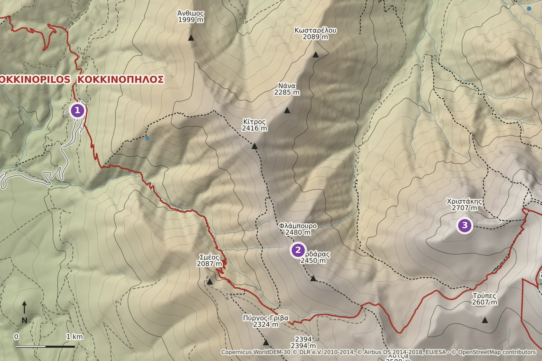
- Kokkinopilos, start
- Flampouro (2,480 m): the path reaches the Flampouro ridge
- Christakis peak (2,707 m), above Laka Christakis and the bivouac
The numbered points are landmarks named in the official route description, in walking order. The path does not necessarily pass over them. The route line will be drawn once a GPX track is available.
Shaded relief with contour lines every 100 m; paths, peaks and refuges from OpenStreetMap. Not a navigation map: carry a proper hiking map such as Anavasi Olympus 1:30,000.
Elevation: produced using Copernicus WorldDEM-30 © DLR e.V. 2010-2014 and © Airbus Defence and Space GmbH 2014-2018 provided under COPERNICUS by the European Union and ESA; all rights reserved. The organisations in charge of the Copernicus programme by law or by delegation do not incur any liability for any use of the Copernicus WorldDEM-30. Map data © OpenStreetMap contributors (ODbL).
A GPX track will be added once the route has been recorded.
Shelters on this route
Christakis bivouac
Unguarded bivouac at Laka Christakis, at the end of the first E4 section from Kokkinopilos. Two buildings, one of them closed.
Maps and further information
- Topoguide: E4 on Mt Olympus, Kokkinopilos – Christakis bivouac (opens an external site)Route description by T. Adamakopoulos; GPX in the Olympus Topoguide app.
- Anavasi hiking map: Olympus 1:30,000 & 1:10,000 (opens an external site)Printed and digital hiking map covering this route (sold separately by Anavasi).
- Olympus National Park Management Agency: mountain routes (opens an external site)
Conditions on the mountain change quickly. This information is a guide only and does not replace your own judgement, a current forecast and proper equipment.